All places › Misima
Bwagaoia Harbour
Anchorage · Misima · Louisiade Archipelago, Papua New Guinea · also called Bwagoia, Bagoia, Misima town
Open Bwagaoia Harbour in the interactive mapHighlights
- Provisions, fuel and cash top-up
- Waterfront walk from the fuel depot to the rocky point at the entrance
- Ride round the island to see villages
The guide
- Position
- 10°41.21'S 152°50.75'E
- Depth
- 4–10 m
- Wind shelter
- good in N, NE, E, W, NW; rolly in SE, S
- Shelter
- Reef breaks the sea but a short chop and small swell roll in with strong S-SE; big swells outside the entrance after strong SW-E.
- Getting in
- Straightforward by day. Depths jump from hundreds of metres to 10 m within ~100 m of the entrance. Lit beacon (Fl W 5s) on the starboard side entering, unlit one to port, both on the reef edges. Leave room for trading boats at the wharves - their anchor lines run out into the bay. Deep keels stop south of the wreck on the east side; it shoals quickly beyond. Small harbour: room for only a few to swing - stern anchor if busy. Airstrip borders the west side.
- Bottom
- thick mud (plastic debris can foul the anchor)
- Holding
- good
- Ashore
- Fuel depot on the waterfront (diesel, petrol, two-stroke "Zoom" - expensive), several trade stores, bakery, Westpac branch (local accounts/forex - don't count on cards), hospital (nurses/health extension officer, no doctor; antibiotics), police, post office, market, guesthouse that does meals, a liquor store. Flights to Alotau/Port Moresby. Gold buyers in town. Cars can sometimes be hired by asking around. Annual "Showcase Misima" cultural festival (around rally time, Sep/Oct).
- Water
- Tap/well water reported as washing-quality; treat or use your own.
- Fuel
- Fuel depot on the waterfront - diesel, petrol and two-stroke. Expensive and sometimes limited (2011-2016 reports).
- Officials
- Not a regular clearance port, but the health/quarantine officer has issued a quarantine certificate here (K50, 2016) and in rally years Customs flew in. Check current rules before relying on it - clear at Alotau.
- Cautions
- Thefts from yachts reported - lock up and don't leave the boat open. In 2016 an armed gang from Alotau raided the shops. Harbour water is dirty (sewage) and crocodiles are possible - not a swimming spot. In a 2010 squall (45 kn) many rafted rally boats dragged - set the anchor well and keep scope.
- Cyclone season
- The US Sailing Directions list a red cyclone mooring buoy in the harbour (a white buoy marks its anchor) - date not given, so ask at the wharf whether it is still there and maintained. The harbour is a narrow inlet (entrance under ~90 m) with mangroves on the north side; local boats lie stern-to the trees on the west side. Swell still rolls in with strong S-SE. A possible refuge, not a proven hurricane hole.
Our sketch map
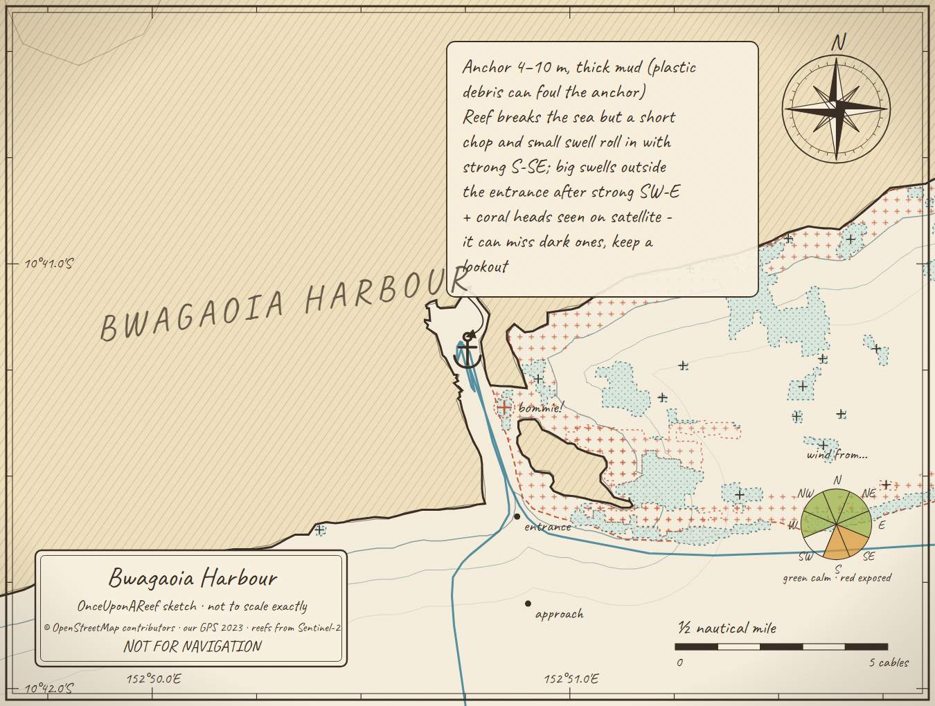
Drawn by us from OpenStreetMap, Sentinel-2 and our GPS. Not for navigation.
More in the Misima
Guluwa (north coast)Siagara (north coast)East LiakEbora - "Hole in the Wall"Maranatha Bay (Bulabulalah)Patnoi (south coast)Bogga Bogga
⛵ Sail with us
This guide is free for everyone, sailor or not: explore the islands and watch our episodes right where they were filmed. The two of us made it from our own visits, footage and a lot of late nights over the maps.
▶ Subscribe to OnceUponAReefFollow along for free on Patreon, or become a member from A$3 a month for exclusive videos, each season's update first and meet-ups. Some memberships include the chance to come sailing with us.
♥ Join us on PatreonOpen the interactive mapSources: compendium p116-121 (Maranatha 2007; Songlines 2011; louisiades.net 2013; 2XS 2016; Opal Lady 2010) · SV Obiwan via Ryan's waypoint (2023) · Cruising Helmsman 2000 · NGA Pub 164 sec 8.45 (public domain)
Thanks to Soggy Paws PNG Compendium, Maranatha guide, SV Obiwan, Cruising Helmsman 2000, NGA Pub. 164: their notes are summarised in our own words.
This guide is a set of personal cruising notes shared in good faith. Information can be out of date or wrong, and positions can be out by hundreds of metres. It is not a substitute for official charts and notices, your own eyes, local knowledge, or professional medical, legal or customs advice. You use it at your own risk: the skipper alone is responsible for the safety of the vessel and everyone on board, and the authors accept no liability for any loss, injury or damage arising from its use.