All places › Central Calvados
Kimuta Island (Renard Islands)
Anchorage · Central Calvados · Louisiade Archipelago, Papua New Guinea
Open Kimuta Island (Renard Islands) in the interactive mapThe guide
- Position
- 10°50.44'S 152°59.23'E
- Depth
- 2.5–8 m
- Wind shelter
- very good in E
- Shelter
- The inner "wharf lagoon" spots avoid the roll the normal anchorage gets in easterlies (very rolly 20 kn+ there).
- Getting in
- Nine waypoints through Dim Dim Passage (route above, WP1 = entrance, WP9 = exit into the anchorage). Locals call the inner spot Maranatha Anchorage. Stern anchor sometimes needed. Land the dinghy right of the rock outcrop.
- Bottom
- sand
- Holding
- good
- Ashore
- The only inhabited Renard island - nice village, good trading. Well water for washing only.
Our sketch map
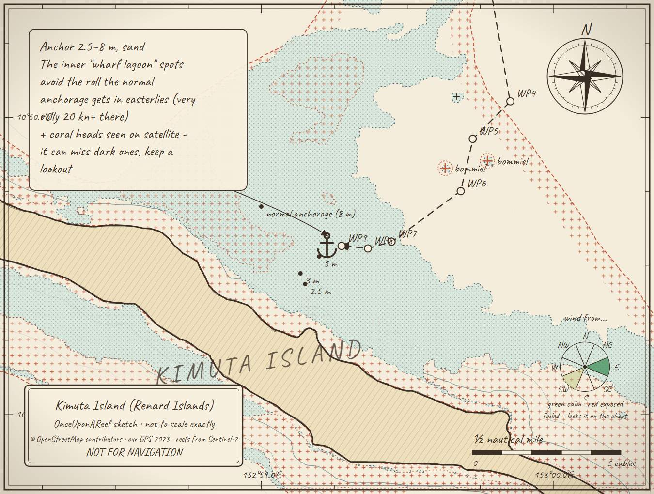
Drawn by us from OpenStreetMap, Sentinel-2 and our GPS. Not for navigation.
More in the Central Calvados
Bagaman NW bay - Chief Noah's villageBagaman NE bay - Oisi village (the carvers)Bagaman south bayBagaman - anchorage 4 (east)Bobo EinaHoba Bay, Pana NumaraPana Numara village - bagi makers (NE side)Blue Lagoon (Madnewan / Leiga lagoon)Gigila Island (Kuwanak village)Robinson's Anchorage, KunawakPana Wina - Pastor Paskel's village (west)Pana Wina north-side creek - CYCLONE HOLEPana Wina - Pana Bali (south side)Pana Wina - SW / river mouthHemenahei IslandSabara (Sabari) lagoonSabra NorthBaiwa islet (Renard Islands)Siwai Wa passage (west side)Chibudi PassDuna Labwa PassagePassage east of Wuri Wuri (no name)
⛵ Sail with us
This guide is free for everyone, sailor or not: explore the islands and watch our episodes right where they were filmed. The two of us made it from our own visits, footage and a lot of late nights over the maps.
▶ Subscribe to OnceUponAReefFollow along for free on Patreon, or become a member from A$3 a month for exclusive videos, each season's update first and meet-ups. Some memberships include the chance to come sailing with us.
♥ Join us on PatreonOpen the interactive mapSources: compendium p113 (Maranatha 2007) · Maranatha web waypoints (Dim Dim Passage)
Thanks to Soggy Paws PNG Compendium, Maranatha guide: their notes are summarised in our own words.
This guide is a set of personal cruising notes shared in good faith. Information can be out of date or wrong, and positions can be out by hundreds of metres. It is not a substitute for official charts and notices, your own eyes, local knowledge, or professional medical, legal or customs advice. You use it at your own risk: the skipper alone is responsible for the safety of the vessel and everyone on board, and the authors accept no liability for any loss, injury or damage arising from its use.